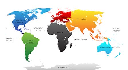
Landmarks in south America
Which are the famous and amazing landmarks in South America?
The natural landmarks and man-made attractions in South America shown below are well known for their unique locations, awe-inspiring natural features or outstanding design and architecture.
Which of the South American landmarks do you recognise? Can you name these landmarks and attractions in South America and locate them on a map?
 Landmarks in South America - impressions
South America houses 12 independent countries and there is a vast number of attractions and landmarks on the continent. Read our South America continent facts here.
There are over 70 UNESCO world heritage sites in South America with Brazil having the most UNESCO sites in South America. Here are 20 of the most well-known monuments and famous landmarks on the South American continent.
What you will find on our Landmarks in South America page:
Top 20 Landmarks in South America
The following landmarks in South America were chosen because they are attract a huge number of visitors each year. All of these landmarks are major tourist attractions in South America and inspiring places to explore.
1 | Machu Picchu in Peru| Landmarks in South America
The ancient ruins of Machu Picchu attract almost half a million visitors each year. This UNESCO World Heritage Site lies high on the slopes of the Andes mountains in the deep jungle of the tropical rainforest of Peru.
 Machu Picchu
The ancient Inca site is located in Peru at an elevation of 2,430 m/ 7,972 ft above sea level.

The name Machu Picchu originates from the Quechua language and means "old mountain". Read more about Machu Picchu.
There are about 200 stone structures of the former citadel with remainders of walls, terraces and temples. One of the most important features is a sacred stone that once was used as a solar calendar. During the equinoxes, when the sun crosses the equator twice a year, the sun sets directly over the stone without casting any shadow.
Most families visit Machu Picchu from Aguas Calientes, which is best reached by a scenic train ride from Cusco. The best time to visit is from May to October, during the dry season.
2 | Amazon River Valley in Brazil
The Amazon river is the world's second longest river and the rainforests of the Amazon river basin are known as the "lung of the earth".
 Amazon
The Amazon River is about 6,400 km/ 4,000 miles long. The river flows through Peru, Colombia and enters the Atlantic Ocean in Brazil. South America's largest country Brazil holds the world's largest freshwater reserves and is the most biodiverse country in the world.
This immense tropical region which includes many rivers and streams in Peru, Colombia, Ecuador and Brazil is fed by the Amazon River, which carries more freshwater than any other river in the world. It accounts for about 20% of the Earth's river water!
Learn more great Amazon Rainforest Facts here.
Most families visit the Amazon River from Manaus in Brazil. The best time to visit is from June to November, during the dry season. There is less humidity and the low river levels are better for hiking and spotting wildlife.
3 | Sugarloaf and Corcovado in Brazil
Sugarloaf mountain's shape is a well known attraction of Rio de Janeiro, but is not the only easily recognisable landmark of Brazil. The peak of this mountain, also called Pão de Açúcar, is located on a peninsula and is 396 m/ 1,299 ft high, and can be reached by cable car.
 Rio de Janeiro
From the top, you can enjoy stunning views of Guanabara Bay, Copacabana and the famous Ipanema beaches.
You can ride to the top of Sugarloaf mountain with a cable car. The granite peak of Sugarloaf mountain received its name from its shape that resembles a traditional cone, which is referred to as sugarloaf - a shape that was already popular in the 16th century.
Did you know?
|
Rio de Janeiro is also known for the statue of Christ the Redeemer on the neighbouring Corcovado peak as seen on the image in the foreground.
Corcovado mountain is 706 m/ 2,316 ft high and thus much higher than Sugarloaf mountain. The Christ The Redeemer statue on top of this mountain overlooks Rio de Janeiro.
Did you know?
|
A scenic cog train ride leads up to the mountain top.
Most families visit Rio de Janeiro in Brazil as part of a longer trip to explore the country. The best time to visit is from December to March, during the Brazilian summer. The famous Carnival in February is an amazing event to visit with music, dancing and colourful costumes. Rio is also well known for its long sandy beaches.
4 | Cathedral of Brasília in Brazil
Another easily recognisable landmark of South America is the Metropolitan Cathedral in Brasília, the capital city of Brazil.
 Brasilia cathedral - image by Robert Napiorkowski
The unique shape of this iconic religious building is created with 16 columns and it has a colourful stained glass ceiling. The cathedral can hold up to 4,000 people.
This UNESCO World Heritage Site is famous and more than one million people visit the Cathedral of Brasília every year. About two thirds of the Brazilians are Roman Catholics and thus Brazil is often referred to as the largest Roman Catholic country in the world.
The modern building was designed by Brazilian architect Oscar Niemeyer and completed in 1970. The building is also known in Spanish as Catedral Metropolitana Nossa Senhora Aparecida.
The capital city of Brazil is easy to reach by flying into Brasília International Airport and travelling into the city by taxi or bus. The best time to visit is during the dry season from May to September, when the weather is warm and sunny.
5 | Mendoza Wine Valley | Argentina Landmarks in South America
The Mendoza Wine Valley is unique for its stunning scenic location in Argentina with the vineyards at the foothills of the Andes mountain peaks. The Andes are the continent's longest mountain range.
 Mendoza wine valley with snowy Andes in the background
The Mendoza valley is the largest wine producing region of South America and internationally recognised as the wine capital of South America.
There are about 800 vineyards in the Mendoza valley. Some of the Medoza vineyards are amongst the world's highest as they are located at elevations of up to 1,520 m/ 5,000 ft.
Most families visit Mendoza as part of a trip in the Andes flying into the city's international airport or travelling by bus from Buenos Aires. The best time to visit is from March to May or September to November, during Autumn or Spring, when the weather is mild and ideal for sightseeing.
6 | Galapagos island in Ecuador | Landmarks in South America
The Galapagos islands of Ecuador are located in the Pacific Ocean about 1,000 km/ 600 miles off the country's coastline.
 Galapagos
Turquoise blue waters, volcanic rock, pristine sandy beaches and the many rare animal species that live here, make the Galapagos an outstanding location on the South American continent.
Ecuador is one of the 17 megadiverse countries and the Galapagos islands are often said to house one of the last unique wildlife zones in the world. Read our Facts about Megadiverse Countries here.
The Galapagos islands are home to marine iguanas, giant tortoises, blue-footed boobies and some other species that are not found anywhere else in the world.
About 225,000 travellers visit the Galapagos islands every year.
Most families visit the Galápagos Islands as part of a longer trip to explore the country. The islands are reached by plane from Quito or Guayaquil in Ecuador and explored by boat between the islands. The best time to visit the islands is from June to November when the weather is cooler and drier, and it is a great time to see marine wildlife.
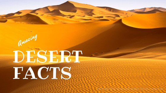
7 | Atacama Desert | Chile
Landmarks in South America
The Atacama desert is the only true hot desert in the world but often referred to as the second driest after Antarctica. Read more about the world's unique deserts here. The Valley of the Moon, Valle della Luna in Spanish, is known for its unique ecosystem and has some stunning hiking trails and extraordinary viewpoints.
 Moon Valley in Atacama desert
Due to the dry air, cloudless sky and high altitude and remoteness the desert is used for astronomical observations. There is no light pollution as in populated areas and thus many telescopes have been placed here by the international scientific community.
The world's largest 'extremely large telescope' (ELT) is currently being constructed on Cerro Amazones mountain in northern Chile. Read more about the ELT here. Note: The 'Very Large Telescope' (VLT) is already operated by the European Southern Observatory (ESO) and a magnificent achievement.
Most families visit the Moon Valley in the Atacama desert as part of a longer trip to Chile's main tourist sites. The site is best reached via flying into Calama and then renting a car or booking a tour. The best time to visit the Atacama Desert is from April to October, when the weather is cooler and very dry.
8 | Angel Falls in Venezuela
Landmarks in South America
The Angel Falls in central Venezuela are the highest waterfalls in the world. The waterfall called Salto Angel in Spanish is 979 m/ 3,212 ft high.
 Angel Falls in Venezuela
The highest waterfall drops from the Ayan mountain is 807 m/ 2,648 ft high. Ayan or Aúyan is a tepui or mountain with a flat top.
Did you know?
|
The waterfalls are difficult to reach as they are located in the middle of deep jungle in Canaima National Park.
If you want to visit the Angel Falls, be prepared for a longer trip. The waterfalls are best reached by boat or a trip through the jungle after you have flown into Canaima. The best time to visit the islands is from June to November during the rainy season as the waterfalls will be so much more impressive. However, do not forget your mosquito repellent!
9 | Lake Titicaca in Bolivia and Peru
Lake Titicaca is the largest freshwater lake in South America and shared by Bolivia and Peru.
 Floating village on Lake Titicaca
Often Lake Titicaca is referred to as the highest lake in South America
The lake on the Altiplano of the Andes mountains is known for the floating islands of the Uros people. The islands are made with sedges or grasses, that grow on the banks of the lake.
Families visit Lake Titicaca mainly as part of a longer trip to Bolivia and Peru's main tourist sites. The lake, however, is best reached via flying into La Paz/ Bolivia and then taking a bus to Copacabana, which is the gateway to Isla del Sol. The best time to visit the stunning lake and the island is from May to October, in the dry season.
10 | Torres del Paine | Chile
- Landmarks in South America
The scenic mountain peaks of the Cordillera Paine in Chile are some of the most well-known mountain peaks in the world.
 Torres del Paine National Park
The three peaks are part of Torres del Paine National Park and are made of yellow granite and are over 2,884 m/ 9,462 ft high.
The Three Towers in Torres del Paine National Park are special because of their tall and sharp peaks that stand alone above the surrounding mountains and valleys.
This makes them look dramatic and breathtaking. The national park in Patagonia with its famous glaciers, turquoise lakes and diverse wildlifeis is often referred to as the "Eighth Wonder of the World" and attracts about 250,000 visitors every year.
Most families visit Torres del Paine National Park in Chile from Puerto Natales which can be reached by flying to Punta Arenas Airport in southern Chile. The best time to visit is from October to April, during the southern summer, when the weather is warmer and the trails are easier for hiking.
11 | Easter Island |Chile
The Easter Island or Rapa Nui as named by the native people is famous for the magnificent huge statues called moais.
 Moais
MoaisEaster Island is a volcanic island located in the Pacific Ocean far off the Chilean coast. Strictly speaking the island belongs to Oceania, but we list it here as part of the South American country Chile.
About 900 large stone statues and over 300 ceremonial platforms are located all over Easter Island.
The name Rapa Nui comes from the indigenous name for the people of the Easter Island. The Rapa Nui people call the island tepito or tehenua, which means 'navel of the world'.
Rapa Nui is the most remote inhabited island of the world. Only about 7,000 people live on the island that is located at a distance of about 3,500 km/ 2,170 miles from continental Chile.
 Chile
ChileIf you plan to visit Easter Island in Chile, then flying Santiago di Chile is the most practical way. The best time to visit is from December to March, during the southern summer, when the weather is warm and sunny and many events and festivals are held on the island.
12 | Nazca Lines in Peru
The Nazca Lines are so called geoglyphs, lines drawn into the soil.
 Nazca lines seen from above
The huge drawings that are as big in area as several football fields were created by the ancient people called the Nazca people, who lived in the area more than a thousand years ago. The Nazca people are said to have created these lines for religious or ceremonial purposes but the full background remains a mystery.
The giant pictures were created by removing the reddish-brown iron oxide-coated pebbles on the surface, revealing the light-colored earth underneath.
The designs include various shapes such as geometric patterns, plants or even animals like spiders, monkeys or birds. The drawings are so big that they can only be fully seen from above which is from a plane, helicopter or the viewing tower which is located near the Pan-American Highway.
The sites of the Nazca Lines can be reached via seven-to eight hour bus ride from the international airport in Lima/ Peru or by local flight to Nazca. The best time to visit is from June to November, during the dry season.
13 | "Middle of the World" in Ecuador
The "Middle of the World" monument, also referred to as "Mitad del Mundo" monument, is placed on the exact location of the equator in Ecuador.
 Middle of the World monument in Ecuador
The equator is an imaginary line dividing the planet into a northern and southern hemisphere. This monument is thus standing at 0 degrees latitude. Here you can actually stand on both hemispheres!
The landmark near Quito refers to the natural landmark of the equator. The unique monument is located in a complex that also includes a museum about the indigenous cultures of the region where you can learn about the country's culture and history.
Most families visit the equator monument with public transport from Quito. The monument can be visited year round.
14 | Ojos de Salado in Chile
Landmarks in South America
The Ojos de Salado is the highest point in the Andes mountain range and in Chile. This natural landmark in South America is the highest volcano on Earth and the second-highest peak in the Southern Hemisphere.
 Ojos de Salado
This volcano is part of the Central Volcanic Zone of the Andes and the summit reaches 6,893 m/ 22,615 ft. second-highest peak in the Southern Hemisphere.
Ojos del Salado is a stratovolcano, which means it is a tall, conical volcano composed of layers of hardened lava, volcanic ash, and other volcanic rocks.
The crater lake on its summit is often frozen due to the extreme high-altitude conditions. The Ojos de Salado is usually referred to as Nevado Ojos de Salado. Nevado means "snowy" and refers to the snow covered peak. The volcano is dormant and lies at the border between Chile and Argentina.
If you want to visit the region, it is best to fly into Copiapó in Argentina and drive from there to Laguna Verde. The best time to visit the region is from December to March, when the temperatures are milder in the high altitudes.
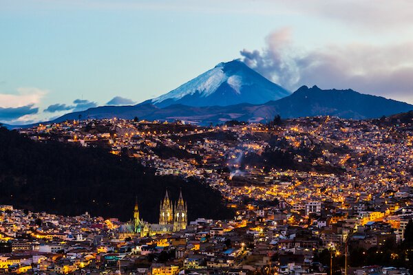
15 | Cotopaxi in Ecuador
Cotopaxi is a snow covered and cone-shaped volcano and one of the highest active volcanoes on Earth. The tall volcano stands at about 5,897 m/ 19,347 ft above sea level.
 Cotopaxi
People from all over the world come to challenge themselves by reaching the top of this famous volcanic mountain.
About 200,000 people visit the national park every year! The volcano is located in a national park called Cotopaxi National Park where you can see llamas, unique birds, and other cool wildlife.
Most families visit Cotopaxi National Park from Quito in Ecuador. The best time to visit is from June to September. Traveling to the national park during the southern winter season will reward with clear views and blue skis and is great for hiking.
16 | Gran Torre de Santiago in Chile
The Gran Torre Santiago skyscraper in the capital city of Chile is the tallest building in South America.
 Gran Torre in Santiago
The building of the Gran Torre was finished in 2013 and measures 300 m/ 984 ft in hight.
The Gran Torre is 62-storeys high and houses one of the largest shopping malls of the continent, the Costanera Center. The observation deck Sky Costanera grants visitors a 360° view of the city of Santiago de Chile and surrounding region.
Santiago de Chile is easily reached by many international airlines flying into Santiago International Airport. The best time to visit is during southern Hemisphere's spring from September to November and southern autumn from March to May, when the weather is dry and mostly sunny.
17 | Salar de Uyuni in Bolivia
The world's largest salt flat is located on the Altiplano of the Andes mountains in southwestern Bolivia. The vast area formed on prehistoric lakes on an elevation of 3,656 m/ 11,995 ft above sea level.
 Salt flat - Salar de Uyuni
The salt pan is almost as large as the island of Jamaica or larger than the US state of Delaware.
Thin layers of water cover the surface of the salt flat that on a calm and clear day resembles the world's largest mirror! The mirror effect of the Salar de Uyuni is most visible during the months of March and April.
There are many layers of salt up to the depth of 10 m/ that are covered by sediments. Beneath the salt crust, the water contains the world's largest deposits of lithium, a metal that is used extensively in various components of laptops, computers, e-cars and phones.
Most families travel to La Paz/ Bolivia and take a tour group from there to the salt flats. Best time to visit is in March and April when the mirror effect of the Salar de Uyuni are most visible.
18 | Perito Moreno Glacier in Argentina | South America Landmarks
The best known attraction in Patagonia is the massive ice field of the Perito Moreno glacier. The toe of the glacier is Lake Argentine, locally called Lago Argentino, which is Argentine's largest freshwater lake.
 Perito Moreno Glacier
Located in the Los Glaciares National Park at the border between Argentina and Chile, Perito Moreno glacier belongs to an ice field that includes 48 glaciers.
Perito Moreno glacier houses the world's third largest fresh water reserve - only the Antarctic and Greenland icefields store more fresh water.
Perito Moreno glacier is one of the very few glaciers that do not shrink due to global warning but grows, however, the reason is not completely understood even by scientists. The ice field is about 4.8 km/ 3 miles wide and 30 km/ 19 miles long. It stands about 74 m/ 240 ft tall above water and in some parts ice is as deep as 700 m/ 2,297 ft.
It is best to visit the glaciers from El Calafate in Argentina. There you take a bus trip to the glacier which is about 75 km/ miles from the town in Patagonia. Best time to visit is from December to February when the temperatures are milder and longer daylight for viewing the glacier.
19 | Iguazu Falls in Argentina
The Iguazu Falls, also spells Iguaçu Falls, are known as the largest waterfall systems in the world.
 Iguazu Falls
The falls are located at the border of Argentine and Brazil, where almost all of Iguazu river basin (95%) is located and the river originates. Most of the waterfalls and jumps, however, are located on the Argentine side.
The water flows and falls over two steps and most of the water then collects in a deep canyon, the Devil's Throat canyon. The Argentina-Brazil border runs through this canyon.
The name Iguazu comes from name the local Tupí people gave to the waterfalls. In the Guaraní language yguasu where 'y' refers to water and 'uasu' means "big".
The edge is of the waterfalls is about 2.7 km/ 1.7 miles long and there are up to 300 smaller waterfalls along that edge. The longest drop is about 82 m/ 269 ft high. The Iguaçu waterfall curtain is broken up by many islands and a stretch of about 900 m/ 2,950 ft has no water at all flowing over the edge.
You can reach the waterfalls from both the Argentinian and the Brazilian side where there are better panoramic views. The Argentinian national park offers better hiking trails. The best time to visit is generally in autumn and spring for less crowds.
20 | Fingers of Punta del Este in Uruguay
Among the most famous sculptures in South America is also 'The Hand', La mano, or also referred to as Los Dedos in Spanish, which means Fingers in English.
 Los dedos - The fingers of Punta del Este
The sculpture in Uruguay was designed by famous Chilean artist Mario Irarrázabal in 1982. He built the sculpture in the sand at Brava Beach in Punta del Este.
Created with concrete and plastic around a steel structure, the sculpture is now one of the most recognised monuments in Uruguay. Only the fingertips of the five fingers of the hand can be seen as they stick out of the sand.
The sculpture was originally named 'Man emerging into life" by the artist and reflects on the influence of humankind in nature.
The sculpture below in the Atacama desert is one of his follow-on projects from 1992. Other hand sculptures by Irarrázabal can be found in Madrid/ Spain and Venice/ Italy.
 The hand in the Atacama Dessert
Best time to visit Los Dedos is during the southern Hemisphere's summer months, December to February, when you can enjoy the stunning beaches nearby.
Popular Pages
 |
 |


 |
 |
Landmarks in South America| Resources
Our page on Landmarks in South America includes these resources:
- Johanna Murphy. "Ten interesting facts about Machu Picchu." WWF. 29 December 2010. Last accessed 30 January 2024
- SkyCostanera. "Educational visits." Skycostanera. Last accessed 30 January 2024
- HSA. "8 Cool Things You'll See in Punta del Este." SpanishAcademy. Last accessed 30 January 2024
- Basilica de Sagrada Familia. "Virtual Tour." SagradaFamila.org. Last accessed 30 January 2024
- Hermitage Museum. "Virtual Visit." HermitageMuseum.org Last accessed 30 January 2024
Images on Landmarks in South America: Wikimedia.com, Shutterstock.com, Canva.com if not otherwise mentioned
Return from Landmarks in South America to Kids World Travel Guide homepage
Competition
2026

Recent Articles
-
EU facts for kids | European Union Basics
May 09, 26 07:53 AM
Our EU facts will provide basic insight and fun facts about the European Union ncluding EU history, member states, locations, symbols and more -
Barbados Facts for Kids: Geography and Culture
Apr 16, 26 09:30 AM
Read Barbados Facts about Bajan food, festivals, turtles, flying fish and more in a country guide created for children, school projects and curious minds. -
Zimbabwe Facts for Kids: Geography, Culture & Wildlife
Apr 15, 26 11:56 AM
Discover Zimbabwe Facts for Kids: Learn about geography, people, animals, famous landmarks, food and economy in this Southern African country.


News for Kids

More Fun Facts


South America Facts
More about Countries in
South America


Animals around the World


Food around the World


View our Pinterest boards
Like us on Facebook
Competition 2026
